Australia maintains over 100,000 kilometres of marked walking tracks—enough trail to circle the Earth 2.5 times. Yet ask any park ranger which question they hear most, and the answer is always the same: “Which one should I actually do?” It’s a reasonable dilemma. The sheer volume of hiking trails Australia offers can feel paralysing, particularly when guidebooks contradict each other and Instagram has turned once-quiet tracks into conveyor belts of influencers chasing the same shot. This resource cuts through that noise—filtering the continent’s walking options through the lens of what actually matters: your available time, your genuine fitness level, and the specific type of reward you’re chasing.
The Diagnostic: Matching Trails to Humans
Most trail guides make the mistake of categorising walks by difficulty alone—beginner, intermediate, advanced. But difficulty is subjective, and a 15-kilometre flat coastal walk demands something entirely different from a 6-kilometre summit climb. The better approach? Start with what you actually want from the experience.
The Time-Poor Wildlife Seeker
If you’ve got a two-hour window and your primary motivation is encountering Australian wildlife in its natural habitat, you need trails where human traffic hasn’t pushed animals deep into the bush. The best day hikes in Australia for this profile aren’t necessarily the most famous ones.
Consider the Wattamolla to Little Marley Beach walk in Royal National Park (4.5km return). It’s accessible from Sydney, delivers wallaby sightings most mornings, and ends at a swimming spot that feels far more remote than its distance from the carpark suggests. The key is timing—arrive before 8am and you’ll share the trail with perhaps a dozen people; arrive at 10am on a weekend and you’ll queue for the water.
The Summit Chaser
For walkers motivated by elevation gain and expansive views, the calculus shifts entirely. You’re trading effort for perspective, and the best hiking trails Australia offers in this category demand honest self-assessment about your cardiovascular fitness.
Mount Warning (Wollumbin) in northern New South Wales exemplifies this profile—4.4km one way, gaining nearly 900 metres, with a final chain-assisted scramble that filters out anyone with genuine fear of heights. The reward? Watching sunrise from the first place the sun touches mainland Australia. But here’s what guidebooks rarely mention: the track closes during adverse weather, and descending that chain section with tired legs tests nerve more than ascending ever did.
The Solitude Seeker
If crowd avoidance ranks higher than convenience, you’ll need to accept certain trade-offs: longer drives to trailheads, basic facilities, and the self-sufficiency that genuine remoteness demands. The best multi day hikes Australia offers for solitude almost always require commitment measured in days rather than hours.
Wilsons Promontory: The Benchmark Walk
Wilsons Promontory National Park occupies a unique position in Australian hiking culture—it’s the reference point against which other coastal walking tracks get measured. Located at Victoria’s southernmost tip, “The Prom” combines granite mountains, pristine beaches, and wildlife density that borders on theatrical. It’s also where many Victorians first encounter the reality that hiking trails Australia offers can demand genuine respect.
Understanding the Trail Personality
The park functions as a tasting menu of Australian hiking experiences. The coastal walks deliver what postcards promise—orange lichen-covered boulders, white sand, and water clarity that makes depth perception unreliable. But the inland tracks reveal something different: dry sclerophyll forest, fern gullies that stay damp year-round, and the occasional grass tree that predates European settlement by centuries.
Squeaky Beach deserves its fame, though the name undersells the experience. The quartz sand genuinely produces sound underfoot—high-pitched and unexpected the first time you hear it. What photographs can’t capture is the acoustic isolation. Walk there at low tide and you’ll hear nothing but your own footsteps, perhaps the distant crash of waves on the headlands, and the irregular thump of alarmed wallabies retreating into the tea tree.
The Accessibility Spectrum
Wilsons Promontory offers trails across the entire difficulty range, making it valuable for understanding your own preferences before committing to more remote best day hikes in Australia.
- Lilly Pilly Gully Nature Walk (2.6km loop): Boardwalk sections, minimal elevation change, excellent for families or testing how children handle bush environments. The rainforest gully stays cool even on 35°C days.
- Mount Oberon Summit (3.4km return): The classic “first summit” experience. Well-constructed track, consistent gradient, and 360-degree views that include the offshore islands. Arrive for sunset and you’ll understand why this trail appears on every Victorian hiking bucket list.
- Sealers Cove (19.5km return): The transition point into serious hiking. Can be done as a long day walk, but many prefer to camp overnight. The tidal river crossing at low tide saves significant distance; at high tide, you’re wading chest-deep or adding kilometres via the inland route.
The Practical Realities
The park’s popularity creates logistical challenges that surprise first-time visitors. Summer weekends require booking accommodation or camping months ahead. The road in becomes a bottleneck on Friday afternoons and Sunday evenings. And the wildlife has learned behaviours that wouldn’t survive in genuinely remote areas—possums at Tidal River will unzip tents if given the opportunity, and wombats have been known to shoulder-check walkers carrying food.
The Continental Matrix: Trails by State and Season
Organising hiking trails Australia by state makes administrative sense but limited practical sense. The better framework groups trails by ecological context and seasonal accessibility—because walking the Larapinta Trail in January versus June represents fundamentally different propositions.
Tropical North: Wet Season Warnings
Queensland’s northern trails operate on a seasonal binary. During the dry season (May to October), tracks like the Thorsborne Trail on Hinchinbrook Island represent some of the best hiking trails Australia offers—32 kilometres of coastal wilderness with crocodile-free swimming holes and camping sites that feel genuinely remote.
The Daintree’s Mount Sorrow Ridge Walk (7km return) exemplifies the tropical hiking proposition. On a clear dry-season morning, the summit delivers views across the reef to the Coral Sea. But the track climbs through rainforest that holds humidity like a sponge, and the return journey tests tired legs on loose, steep terrain. This isn’t a walk for anyone uncertain about their fitness.
Alpine Regions: Seasonal Access
Victoria’s Alpine National Park and New South Wales’ Snowy Mountains offer best multi day hikes Australia has for mountain terrain—but only during the snow-free months. The Australian Alps Walking Track (650km end-to-end) represents the pinnacle of Australian long-distance walking, crossing three states and requiring three weeks for a full traverse.
For more accessible alpine experiences, Mount Bogong (Victoria’s highest peak) offers a 16km return day walk from Mountain Creek. The track is well-marked and the 1,800-metre elevation gain spreads over enough distance to feel achievable for reasonably fit walkers. What catches people out is the weather—alpine conditions can shift from clear to whiteout within hours, even in summer.
Desert Interior: Temperature Windows
Central Australia’s walking tracks exist within narrow temperature windows. The Larapinta Trail (223km end-to-end) ranks among the world’s great desert walks, but only between April and September. Outside those months, daytime temperatures regularly exceed 40°C, making the multi-litre water carrying requirements feel inadequate.
Sections 1-3 of the Larapinta can be done as day walks from Alice Springs, offering an accessible taste of desert hiking. The Telegraph Station to Simpsons Gap walk (17.5km one way) delivers the quintessential West MacDonnell Ranges experience—gaps carved through ancient ranges, permanent waterholes, and the particular silence that only desert landscapes produce.
Temperate Coastal: Year-Round Accessibility
Southern Australia’s coastal regions offer the most forgiving conditions for year-round walking. The Great Ocean Walk (104km end-to-end) represents Victoria’s flagship multi-day coastal experience, but its day sections work equally well for walkers not ready for overnight commitment.
Western Australia’s Cape to Cape Track (135km) delivers similar coastal drama with fewer crowds. The limestone cliffs, karri forests, and reliable spring wildflower displays make it one of the best hiking trails Australia offers for walkers seeking manageable multi-day experiences with bail-out options.
The Unspoken Variables: What Trail Guides Don’t Tell You
Guidebooks and trail websites focus on distance, elevation, and featured attractions. They rarely address the variables that genuinely shape your experience—the factors that determine whether a walk becomes a highlight or an ordeal.
Mobile Reception Reality
The assumption of connectivity shapes behaviour in dangerous ways. Many hiking trails Australia offers have zero mobile reception for their duration—not intermittent reception, but genuine dead zones where emergency communication requires personal locator beacons (PLBs).
Even trails relatively close to urban areas can lack coverage. The Blue Mountains’ more remote tracks, despite being within 100 kilometres of Sydney, include sections where you’ll see the city’s glow at night while having no way to call for help. This isn’t fear-mongering—it’s the baseline reality of Australian wilderness.
Water Source Reliability
For day walks, carry everything you need. For multi-day walks, contact the relevant parks office within a week of departure for current water reports. The few minutes spent on that phone call can prevent situations where dehydration forces risky decisions.
The Footwear Conversation
Northern hemisphere hiking advice doesn’t translate to Australian conditions. Our trails combine granite, sandstone, and loose decomposed granite in ways that punish footwear designed for European or North American surfaces. The “one boot fits all” approach fails here.
For coastal and sandy conditions, lightweight trail runners often outperform heavy boots—they drain faster when wet and reduce fatigue over long distances. For rocky terrain (the Overland Track’s dolerite, the Flinders Ranges’ shale), proper ankle support becomes genuinely valuable. For tropical walks, quick-drying materials matter more than waterproofing—your feet will get wet from humidity regardless of boot claims.
Wildlife Encounter Protocols
Snake encounters represent the most common wildlife concern on hiking trails Australia offers, but the actual risk doesn’t match the anxiety. Eastern brown snakes, tiger snakes, and red-bellied black snakes all occur along popular walking tracks, but they’re also reluctant to engage with humans.
The protocol is simple: stop, let the snake determine its exit path, and wait. Most snakes will retreat given the opportunity. Striking is a last resort—they know that envenomation costs energy and venom they need for hunting. Step on a rock or log, not over it, so you can see what’s on the other side first. And if you hear rustling in undergrowth, pause rather than push forward.
Booking Systems That Catch People Out
Many international visitors (and plenty of Australians) assume that walking tracks are freely accessible year-round. The reality is more complex. Popular tracks like the Overland Track, Larapinta Trail, and Hinchinbrook Island require permits and have limited daily quotas. Wilsons Promontory camping bookings, as mentioned, require advance planning during peak periods.
The fees serve genuine conservation purposes—track maintenance, toilet facilities at remote sites, ranger presence in areas where self-sufficiency fails. But they also mean that spontaneous “let’s do the Overland Track this weekend” plans don’t work. Research booking requirements before you fall in love with a specific trail.
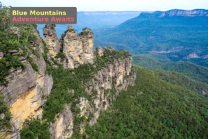
When the Trail Differs from the Hype
Social media has created a phenomenon where certain trails attract crowds disproportionate to their actual quality. The Three Sisters walk at Katoomba delivers exactly what it promises—iconic views of an iconic formation—but the experience of sharing those views with hundreds of simultaneous visitors, many treating the track as a photo studio rather than a nature experience, can feel underwhelming.
The nearby Federal Pass track (from Echo Point to Leura Forest) offers a more complete experience: descents through fern gullies, historical coal mining sites, and the particular atmosphere that comes from walking beneath cliff faces rather than above them. It requires more effort, sees fewer visitors, and delivers a more complete Blue Mountains experience. Sometimes the best trail is the one beside the famous one.
From Day Walks to Multi-Day: The Progression Logic
The jump from best day hikes in Australia to best multi day hikes Australia offers isn’t just about carrying more gear—it’s a fundamental shift in self-sufficiency, risk management, and psychological approach.
What Actually Changes
Equipment requirements scale, but not in the ways most people expect. The critical additions aren’t the obvious ones (tent, sleeping bag, stove) but the backup systems: water purification for when carried water runs short, comprehensive first aid that goes beyond blister management, navigation tools that work when phone batteries die.
Mental preparation matters equally. Multi-day walking requires accepting discomfort as a baseline condition—something will hurt, something will be annoying, and the weather won’t cooperate at least once. The question isn’t whether challenges arise, but how you’ll respond when they do.
Day Hikes as Training Grounds
Certain day walks serve as excellent preparation for specific multi-day objectives:
- Mount Feathertop via Razorback (Victoria): The exposed ridge walking prepares you for the Overland Track’s more exposed sections, while the long descent builds the knee resilience that multi-day walking demands.
- St Mary Peak (South Australia): The Flinders Ranges’ highest peak delivers terrain that prepares you for the northern Larapinta sections—rocky, exposed, and requiring consistent navigation attention.
- Mount Ossa (Tasmania): Tasmania’s highest peak involves the scree and boulder-field travel that characterises many best multi day hikes Australia offers in alpine regions.
The Multi-Day Gateway Experiences
Not ready for a week-long commitment? These two-night options bridge the gap between day walking and serious trekking:
The Hinchinbrook Island Thorsborne Trail (Queensland): 32 kilometres over four days (easily compressed to three), with camping sites that feel genuinely remote despite the track’s fame. The creek crossings and tidal timing requirements introduce multi-day planning complexity without extreme consequences for minor errors.
The Three Capes Track (Tasmania): 48 kilometres over four days, with built-in accommodation that removes camping complexity while delivering world-class coastal scenery. The managed experience makes it accessible for walkers nervous about wilderness self-sufficiency, while the terrain provides genuine challenge.
Key Takeaways
- Match trails to your actual motivations (wildlife, views, solitude) rather than generic difficulty ratings
- Wilsons Promontory serves as Australia’s benchmark coastal hiking experience—visit it to calibrate your preferences
- Seasonal timing matters more than destination selection—the same trail in different seasons is a different experience
- Mobile reception is unreliable on most genuine hiking trails; carry appropriate communication equipment
- Multi-day progression requires mental preparation, not just additional equipment
The Curated Shortlist: One Walk Per State
If you’re building a lifetime Australian walking wishlist, these are the trails that deliver the most complete experience in each state:
| State | Trail | Why This One |
|---|---|---|
| New South Wales | Grand Canyon Track, Blue Mountains | Technical descending, fern gullies, and canyon atmosphere unlike anything else accessible by public transport from Sydney |
| Victoria | Sealers Cove, Wilsons Promontory | The complete coastal wilderness experience—beach, forest, wildlife, and genuine remoteness within day-walk distance |
| Queensland | Thorsborne Trail, Hinchinbrook Island | Tropical coastal hiking at its finest, with swimming opportunities and minimal development |
| Western Australia | Cape to Cape Track (sections) | Cliff-top walking, karri forest, and reliable wildflower displays during spring |
Be the First to Comment
Sign in to start the conversation.